• Home
  • Taiwan Hiking Map
  • About
    • About Me
    • Liability Disclaimer
  • Contact
  • Language:  English
    • English  English
    • 中文 (台灣)  中文 (台灣)
OutRecording
Menu
  • Home
  • Taiwan Hiking Map
  • About
    • About Me
    • Liability Disclaimer
  • Contact
  • Language:  English
    • English  English
    • 中文 (台灣)  中文 (台灣)
Home  /  Taiwan Off-Roading  /  Maolin Entrance Trail – Pt 1 (Weiliao Mountain Trail – 尾寮山步道)
21 April 2017

Maolin Entrance Trail – Pt 1 (Weiliao Mountain Trail – 尾寮山步道)

Written by Glenn
Taiwan Off-Roading Kaohsiung, KLX250s, Lover's Gorge Waterfall, maolin, mountains, Tailiao Mountain Trail, Taiwan, 尾寮山步道 1 Comment

Ride Info

This is the first part of a two or more part ride. I started the ride on the other side, near Lover’s Gorge waterfall. But I would recommend starting where I finished, at the trail head of Weiliao Mountain Trail (尾寮山步道).

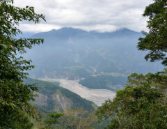
As you travel up you’ll first come to a fork here 22.874828 120.648072. There’s a pavilion nearby that everyone seems to like. For some reason I didn’t go, but I would recommend taking a look. From here take the trail to the right. You’ll zigzag up for a while and eventually come to the gates of someone’s house here 22.871856 120.651297 Take the road to the right that goes around the house and you’ll end up at a nice lookout point with some seating. Beyond this point it didn’t look too motorcycle friendly so I turned back.

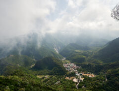
Head back down to the fork and take the other trail. This one didn’t have any hikers and was in slight disrepair. You’ll find a great view of the Maolin visitor center before you cross to the other side. It gets a little sketchy in places, so best have decent offroad tires. The trail splits here 22.876579, 120.662112. The trail to the right takes you to a dead end. It looks like farmers use it to run PVC to get water. If I remember right, there was a path you could take by foot. Could be a waterfall beyond, but don’t quote me.

When you exit, I’d highly recommend a visit to Lover’s Valley Waterfall. You can drive right up to this waterfall. The upper falls, Lovers’ Gorge, take maybe 10 ~ 15 min of stair walking at a leisure pace. More info here: Lovers’ Gorge.


Ride Start:

22.879630, 120.645413


Date:

2015 July 15


Notes

I went on a Wednesday and there were a fair amount of hikers and mountain bikers in the beginning. Please be aware of them and try not to piss them off.


Click here for Part 2 of this ride


GPX Track Download Instructions: Click the track on the map to see the download link


Gallery

2015-07-15 11.21_web.27
2015-07-15 11.21_web.31
2015-07-15 11.22_web.10
2015-07-15 11.22_web.14
2015-07-15 11.28_web.17
2015-07-15 11.28_web.27
2015-07-15 11.28_web.31
2015-07-15 11.28_web.37
2015-07-15 11.34_web.52
2015-07-15 11.34_web.59
2015-07-15 11.35_web.02
2015-07-15 11.38_web.15
2015-07-15 11.38_web.17
2015-07-15 11.41_web.37-2
2015-07-15 11.41_web.39
2015-07-15 11.41_web.44
2015-07-15 11.42_web.13-1
2015-07-15 11.46_web.57
2015-07-15 11.47_web.47
2015-07-15 11.51_web.40
2015-07-15 12.03_web.56
2015-07-15 12.04_web.10
2015-07-15 12.04_web.15
2015-07-15 12.30_web.31
2015-07-15 12.30_web.37
2015-07-15 12.31_web.01
2015-07-15 12.31_web.40
2015-07-15 12.31_web.46
2015-07-15 12.35_web.02
2015-07-15 12.43_web.41
2015-07-15 12.43_web.49
2015-07-15 12.50_web.31
2015-07-15 12.50_web.34
2015-07-15 12.50_web.44
2015-07-15 12.52_web.51
2015-07-15 12.53_web.06
2015-07-15 12.53_web.13
2015-07-15 12.54_web.36
2015-07-15 12.54_web.49
2015-07-15 13.04_web.24
2015-07-15 13.04_web.29
2015-07-15 13.05_web.10
2015-07-15 13.05_web.48
2015-07-15 13.17_web.59
2015-07-15 14.22_web.17
2015-07-15 14.25_web.05
2015-07-15 14.27_web.12
2015-07-15 14.27_web.25
2015-07-15 14.30_web.26
2015-07-15 14.30_web.42
2015-07-15 14.33_web.13
2015-07-15 14.52_web.48-1

Liability Disclaimer

Please read the Liability Disclaimer before using any information within this post, page or any part of this website.

Share On
Share on Facebook
Share on Twitter
Share on Pinterest
Share on Reddit
 Previous Article Strengthening KLX250S Subframe
Next Article   Maolin Entrance Trail – Pt 2

Related Posts

  • Exploring Abandoned Mountain Roads in Taiwan Along the Shaxi Forest Road (沙溪林道)

    November 18, 2024
  • Exploring an Abandoned Forestry Bureau Building

    July 15, 2024
  • WeiLiaoShan North Peak 尾寮山北峰 featured image

    WeiLiaoShan North Peak – 尾寮山北峰 Exploratory Route

    March 13, 2023

1 Comment

  1. Pingback: Maolin Entrance Trail – Pt 2 | Out Recording

Leave a Reply Cancel reply

Hiking in Taiwan & Offroad Motorcycling

Recent Comments

  • Glenn on Importing a Satellite Phone into Taiwan
  • Mark on Importing a Satellite Phone into Taiwan
  • Glenn on Hike to PingBuCuoShan, CaoShan, NanHuLuShan West Peak – 坪埔厝山, 草山, 南湖呂山西
  • Allen T. on Hike to PingBuCuoShan, CaoShan, NanHuLuShan West Peak – 坪埔厝山, 草山, 南湖呂山西
  • Gerard Lardner on Tascam DR-680 Noise Test
TAIWAN RELATED OUTDOORS BLOGS & SIMILAR TOPICS

Categories

PRIVACY POLICY

Tip Jar

Find something useful? Click the jar to buy me a coffee or send a little more to help with my hosting costs, or heck, why not a shit ton of cash to buy me a new motorcycle!? ...the choice is yours. But really, any amount is appreciated!

Copyright © 2023 by outrecording.com. All Rights Reserved. Please read this Disclaimer / Privacy Policy before using any information on this site.

  [Valid RSS]