

Along the first half of the Shaxi Lindao trail are three minor peaks that I’ve dubbed the “Shaxi Lindao Triumvirate”. As sinister as that may sound, they’re not all that difficult. Well, two of them at least.
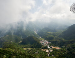
The Shaxi Lindao (沙溪林道) is one trail that nobody should miss hiking or driving. Once at the top you can drive 19 kilometers deep into the mountains and possibly another three kilometers if you can get past a small dip in the trail. Otherwise it’s easily hike-able until you get to the massive landslide that destroyed a large part of the trail. I haven’t hiked beyond the landslide but old maps show that the trail used to go much, much further.
More info on the Shaxi Lindao in my posts here:
Getting back to the Triumvirate, ShaKaLan, NanWeiliao, ZuoMuBei (莎卡蘭山, 南尾寮山, 佐母背山) I wasn’t sure which order to hike them but read that ZuoMuBei was more difficult, so I saved it for last. ShaKaLan was the first peak I would pass once near the top, so I opted to hike it first.
ShaKaLanShan 莎卡蘭山
Getting to the trailhead was simple. I was able to ride up it a bit and find a nice place in the shade to park my bike. After a very short hike I reached a small rock-slide.

The rock-slide looked somewhat recent. I had to climb over it and none of it felt stable. This would be the only dangerous part of the entire hike.
The rest of the way was relatively easy. Not simple, but easy. But you still had to do some leg work up the mountain…


Near the top I ran into a tangled mess of a trail.

My GPX track told me to go straight through it. I wasn’t feeling much up to hacking my way through, so I found an alternate route around it. A short hike later and I was at the top.


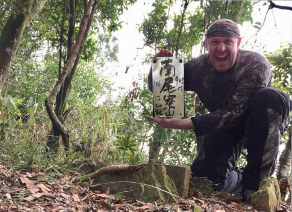
There was no sign to hold, so I carefully took that little metal placard off the tree to hold.
In total it took me about an hour to hike to the top…and there was no view, so I did a little machete work to create my own view.


Little did I know, this would be the best view at a peak I would get all day. However, the views from the Shaxi Lindau were as great as always.
On my way down, I found something I’ve never encountered before. No explanation needed…

NanWeiLiaoShan 南尾寮山
From ShaKaLanShan I rode 7 kilometers to the next trail head. It is located right next to the chain “preventing” you from going to the restricted area of the Shaxi Lindau. I must have passed this dozens of times over the years and never knew it was there. If you haven’t figured it out yet this is the southern tip of WeiLiaoShan, a popular peak in the Maolin area. I hiked there from the back trail, which also begins on the Shaxi Lindau. I wrote about it here: http://outrecording.com/Z79cJ
The hike to NanweiLiaoShan was extremely simple; it was downhill the whole way.

There was very little of interest to see in the thirty minutes it took me to get to the peak, except this random cable someone stuck to a tree.

The peak itself was pretty nondescript.


One point of interest though is this sign. I’m told it was left by the Nanzhou Sugar Factory hiking club, and that the factory had closed down in 2003. So that sign was placed there quite a long time ago!

Like the last peak, this one also didn’t have a sign for me to hold. And I couldn’t remove a sign from a tree like I did before. So…I improvised!

A quick and dirty picture edit later…
Well…it worked at least! Hahaha…
This peak had a spot with a view. But it was hazy out and I felt it wouldn’t make for a good picture so I didn’t take any. 🙁
I would definitely recommend these first two peaks with a ride on the Shaxi Lindau in between for a nice little day hike and/or ride. Don’t take a four wheel vehicle unless it’s a 4WD. A scooter is possible though. If you get there early enough and are up for a challenge, then proceed on to the last peak.
ZuoMuBei 佐母背山
A one kilometer drive back the way I came took me to the ZuoMuBei trailhead. I should have eaten lunch at this point but thought I could finish the final peak and eat afterwards. Big mistake…
The first two peaks were just a tease. ZuoMuBei was more like an actual Taiwan hike: a leg burner!
It starts at a dry rocky stream.

You take this up a bit and connect with an old farmer road network. I hadn’t known this existed. It was unfortunately abandoned. Otherwise it would have been a much easier hike. Judging by the size of the trees growing in the middle of the road, I’d say it was abandoned at least 20 to 25 years ago…if not longer. Switchback after switchback…side roads, etc, all up there…all gone.
It seems Taiwan hikers don’t care much to follow switchbacks; the trail cuts right up the middle of them. It wasn’t so bad though because the vegetation wasn’t dense. There was plenty of room to navigate however you pleased. At some point I realized I was in a race against time, so I didn’t take many pictures. That is, until I made it to the ridge and found myself in the middle of a bamboo forest. 🙁


I can’t tell you how disheartening it is to have to navigate through this much bamboo. I’ve been on some trails like this where enough people go through that the trail is easy enough to follow. But this trail probably doesn’t get hiked much. There was no path at all. I couldn’t go around. It was hack my own path or turn around. And believe me, I almost did turn around. But I’m stupid stubborn at times so I pushed forward.
Eventually it thinned out and I was back to a normal forest. A final push up the mountain and I made it to ZuoMuBeiShan 佐母背山! It was quite anti-climactic. No view at all and just a circle patch of cleared land with a triangulation point in the center.

To make it worse, I could hear all the city noises from the other side. It would have been a great view if all that vegetation wasn’t in the way. Oh well…at least I made it here.

My way back down is where not eating lunch took its toll. To go down I had to go up – up through the bamboo forest. It wasn’t as bad as before but really zapped my energy. Right when I got out of it, it started getting dark.
The rest of the way was routine but I did hear something that I couldn’t explain. Well, I could…it was some animal. But it sounded like…have you ever seen The Walking Dead? Yes, it sounded exactly like a “walker” (zombie). I kind of chuckled to myself…I mean, hearing a zombie-like sound alone at night in the middle of nowhere in the mountains…😂. And to top it off, my path took me directly towards it. Needless to say, I took a small detour just in case.
Any clue what animal in Taiwan would make such a noise? If I had to guess, I’d say it was in a tree.
Good times!
(Oh yeah, and per my modus operandi, it DID rain for maybe 15 min on the way to the final peak. The canopy kept it off me. I’m a rain magnet I tell you!)
Here’s a map with the peaks marked for your reference.

Date Hiked: 2018 Nov 30
GPX Track Download Instructions: Click the track on the map to see the download link

![[Valid RSS]](https://outrecording.b-cdn.net/wp-content/uploads/2020/03/valid-rss-rogers.png.webp)
發佈留言