• Home
  • Taiwan Off-Roading
  • About Me
    • About Me
    • Liability Disclaimer
  • Contact
  • 語言: 中文 (台灣)
    • English English
    • 中文 (台灣) 中文 (台灣)
OutRecording
Menu
  • Home
  • Taiwan Off-Roading
  • About Me
    • About Me
    • Liability Disclaimer
  • Contact
  • 語言: 中文 (台灣)
    • English English
    • 中文 (台灣) 中文 (台灣)
Home  /  Taiwan Off-Roading  /  Shaxi Lindau Trail – After Guard Station
13 五月 2016

Shaxi Lindau Trail – After Guard Station

Written by Glenn
Taiwan Off-Roading campsite, KLX250s, mountains, Shaxi Lindau Trail, Taiwan 1 Comment

Sorry, this entry is only available in 美式英文

Ride Info

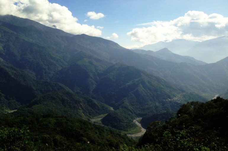
This is the second half of the Shaxi Lindau trail. It takes you nearly 15 kilometers into the desolate mountains with not a soul to see. In full, the whole Shaxi Lindau trail starting from the 185 comes in at just over 31 kilometers. That’s 62 kilometers there and back. A great day’s ride! By far one of my favorites.

This ride starts at the a “chain gate” here 22.816692,120.6772326. The second time I rode to this point I saw a few mountain bikers exiting around the pole on the right. It was late in the day so I planned to give it a try the next time I came out. A smaller motorcycle can make it around no problem. I’m not sure about a larger one – perhaps with some help.

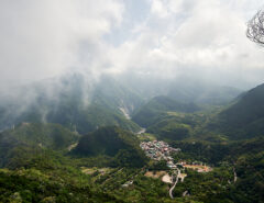
Just beyond the gate is a guard shack. The last several times I went it was locked up tight. The door appears to be riddled with gun shots from the INSIDE. Makes my mind wonder what happened there and why there is no longer a guard there…

One time I went there was a construction crew several kilometers in. I thought they would tell me to go back, but instead invited me to eat with them. 🙂

Beyond that was just pure riding. Mostly double track. Nothing technical, so you can practice maneuvering at higher speeds. There’s always the worry that another rider or truck will be waiting around the next corner, so consider that. Though I only saw others on the first half of the trail…not after the guard shack.

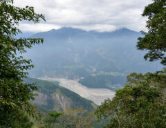
That last kilometer or two becomes a little hairier, down to single track, but not so bad. The trail ends prematurely at a landslide – another victim of a typhoon I’m sure. It’s really too bad. Looks like there’s a lot more trail beyond that. 🙁  Those road crews were fixing stuff, and that gives me hope they may want to fix the trail beyond this point…but only a little hope. It also looked like they were doing a lot with the trees on either side of the trail. Whatever it is, I’m happy work is being put into it.


Ride Start:

22.816692,120.6772326


Date:

2015 Nov 30


Notes

  • There’s an abandoned building here: 22.872419 120.697753  I didn’t explore it or know what it used to be. Maybe next time.
  • The back trail to Weiliaoshan is here: 22.862433 120.683869. It’s a relatively short hike. I hiked it in April 2018.   
  • The trail ends here: 22.871211 120.726836  There’s evidence of people camping here. Likely a good place to set up your tent.
  • Please keep in mind that where there are closed gates and guard shacks (even abandoned ones) you most likely are not supposed to be in there. You assume all responsibility for going in there.


GPX Track Download Instructions: Click the track on the map to see the download link

Map loading, please wait ...


Gallery

2015-11-30-11.11.10-1
2015-11-30-11.11.24
2015-11-30-11.13.50
2015-11-30-11.19.41
2015-11-30-11.20.08
2015-11-30-11.20.27
2015-11-30-11.38
2015-11-30-11.35.32
2015-11-30-11.46.11
2015-11-30-11.51.04
2015-11-30-11.54.21
2015-11-30-11.54.25
2015-11-30-11.54.44
2015-11-30-11.56.31
2015-11-30-12.06.48
2015-11-30-12.06.51
2015-11-30-12.06.54
2015-11-30-12.07.47
2015-11-30-12.24.42

[Show slideshow]

Share On
Share on Facebook
Share on Twitter
Share on Pinterest
Share on Reddit
 Previous Article Turning a Jackhammer into a “Ghost Train” Sound Effect
Next Article   Taiwan Riverbed Riding – Winter 2016

Related Posts

  • Green sign with red lettering in Chinese - BeiHuLuShan 北湖呂山

    (English) BeiHuLuShan 北湖呂山 – Alternative Shorter but Steeper Route

    一月 9, 2020
  • WeiLiaoShan Hike – 尾寮山

    十二月 25, 2019
  • ZuMuShan featured image - mountains and rivers below

    ZuMuShan 足母山 – A Peak with a Secret at the Top

    十二月 4, 2019

1 Comment

  1. 自動引用通知: Maolin Entrance Trail - Pt 2 - Out Recording

發佈留言 取消回覆

Hiking in Taiwan & Offroad Motorcycling

  • Popular Posts
  • Recent Posts
  • Tascam DR-680 Noise Test 一月 16, 2014 10
  • 巴層巴墨山的登山趣, 屏東縣獅子鄉, 台灣 三月 3, 2019 4
  • Down But Not OUT! SPS200 Noise Problem 四月 2, 2014 4
  • Taiwan Round Island Dirt Trip – Day 01 一月 19, 2018 4
  • MeiLunShan 美輪山 trail sign
    (English) Hiking to MeiLunShan – 美輪山, in Kaohsiung, Taiwan 十二月 17, 2020 0
  • (English) Return to Tjuqemadris, Return to Roots 十一月 11, 2020 0
  • rolling green mountains - blue sky and ocean - white clouds
    (English) Hike to QiLuZhiKeShan – 耆路知可山 in Shihzih, Pingtung County 十月 26, 2020 0
  • Mountain landscape - riverbed below - blue sky and white clouds
    (English) Hike to LaiYiShan & ZhenYaSheShan – 來義山 & 真雅社山 七月 30, 2020 0


OutRecording @OutRecording
5
Spending a couple days on the opposite coast this week.
#taiwan #NotOutHiking https://t.co/kNGXsGBBtO

- 3 hours ago

Follow @outrecording

Social Media

  • Connect on Twitter
  • Connect on Instagram
  • Connect on YouTube
MY HIKING GEAR SPONSOR

Six Moon Designs Logo

近期留言

  • 「Glenn」在〈(English) An Easy Hike to ZhuoDiLuoLiuShan – 著地螺留山〉發佈留言
  • 「Tim」在〈(English) An Easy Hike to ZhuoDiLuoLiuShan – 著地螺留山〉發佈留言
  • 「Glenn」在〈(English) An Amazing Hike on the QiYueZongZou – 旗月縱走 Ridge Trail〉發佈留言
  • 「Tim」在〈(English) An Amazing Hike on the QiYueZongZou – 旗月縱走 Ridge Trail〉發佈留言
  • 「Glenn」在〈(English) Hike to FangYeJuShan, Rock Peak 425, and KaYouFeng Waterfall – 枋野具山 & 425岩峰 & 卡悠峯瀑布〉發佈留言
TAIWAN RELATED OUTDOORS BLOGS & SIMILAR TOPICS

分類

  • Equipment
  • Field Recording
  • General
  • Hiking
  • KLX250S
  • Mods
  • News
  • Sound Map
  • Taiwan Off-Roading
  • Taiwan Related Audio

  • 29

Random Posts

  • Green pool of water in mountain ravine
    瓦魯斯溪之旅 三月 30, 2019
PRIVACY POLICY

Copyright © 2020 by outrecording.com. All Rights Reserved. Please read this Disclaimer / Privacy Policy before using any information on this site.

 [Valid RSS]