


After my discovery hike five days earlier, I got a wild hair up my ass and decided to hike the same ridge in its entirety. It would be a long hike–every bit of which I’ve hiked before in pieces–but one that would pass by seven peaks. I felt it would be a fun hike, and it was!
The ridge I speak of is located in Laiyi Township (來義鄉).
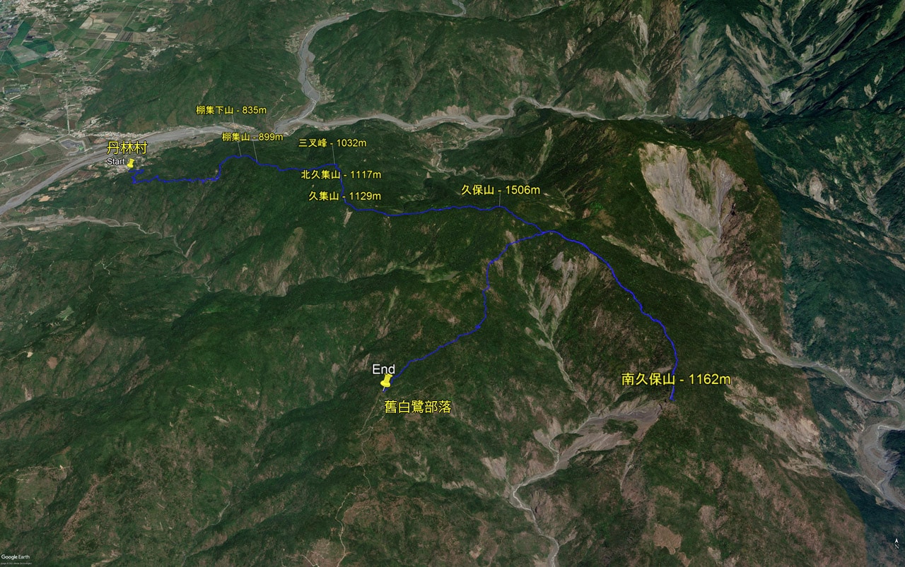
You can either start at the north end trail head in DanLin Village (丹林村) or at the south end near the Old BaiLu Tribe (舊白鷺部落). Starting from the southern trail head would be the easier hike, as you’ll need to drive up the mountains a good ways, making most of the hike downhill. But that leaves a problem. Unless someone drives you up there and drops you off, you’ll need to have someone drive you back to get your transportation. I guarantee it will be dark. I personally didn’t want to drive back up the mountains in the dark…and then back down.
My other thought was, “Why take the easy route anyway!? More difficult or nothing!” Or something like that.
But I still knew I would need to have someone pick me up at the other end. Thankfully my friend Shereé learned about my hike and graciously volunteered to wait for me and then drive me back to my motorcycle. I couldn’t have done this hike without her. So another thanks to Shereé!
If all went as planned, I would pass by seven peaks (though one I suspect isn’t really a peak): PengJiXiaShan, PengJiShan, SanChaFeng, BeiJiuJiShan, JiuJiShan, JiuBaoShan, and NanJiuBaoShan – 棚集下山, 棚集山, 三叉峰, 北久集山, 久集山, 久保山, 南久保山 – SanChaFeng being the one I’m skeptical about.
A Plan is Born
With everything planned, I got up really early and drove out to DanLin Village. When I arrived I had a solid hour of darkness ahead of me. I was sure I would be the first and only hiker there that early, but I was wrong. I had parked a short distance away from the village because my motorcycle is somewhat loud and I didn’t want to piss off the sleeping locals. Well, apparently not everyone thinks like this.
As I walked up to the trail head at the side of the road near many houses, there was a man with a couple dogs also about to set off. His dogs were barking and he had a portable speaker that was BLARING music. I was half surprised and half like…well, ok that somehow makes sense to me. Whatever… I waited and let him go first.

Seeing how it was dark and my camera has a small sensor, I didn’t want to take many pictures for this part of the hike. And it’s not like there was much to see anyway.

Now would be a good time to mention that there are two trail heads in DanLin that go to PengJiShan 棚集山. The other is a little ways down the road from the trail head I took. It follows a road up and I’d say somewhat easier–if not longer–than the trail I took that day. If you’re interested in that one, here is a link to a post where I took that route down from PengJiShan. As I mention multiple times in that post, DON’T follow my route up the mountain. Just follow that GPX track backwards until you get there.
I Can See the Light
Speaking of that mountain road, I found that the trail I took hooks up with the road.

The first time I was here a year and a half ago I took a break at this covered area.

The trail is behind and to the left of this covered area. If you’re coming down from PengJiShan, opt for the trail if you have energy. It should be faster.
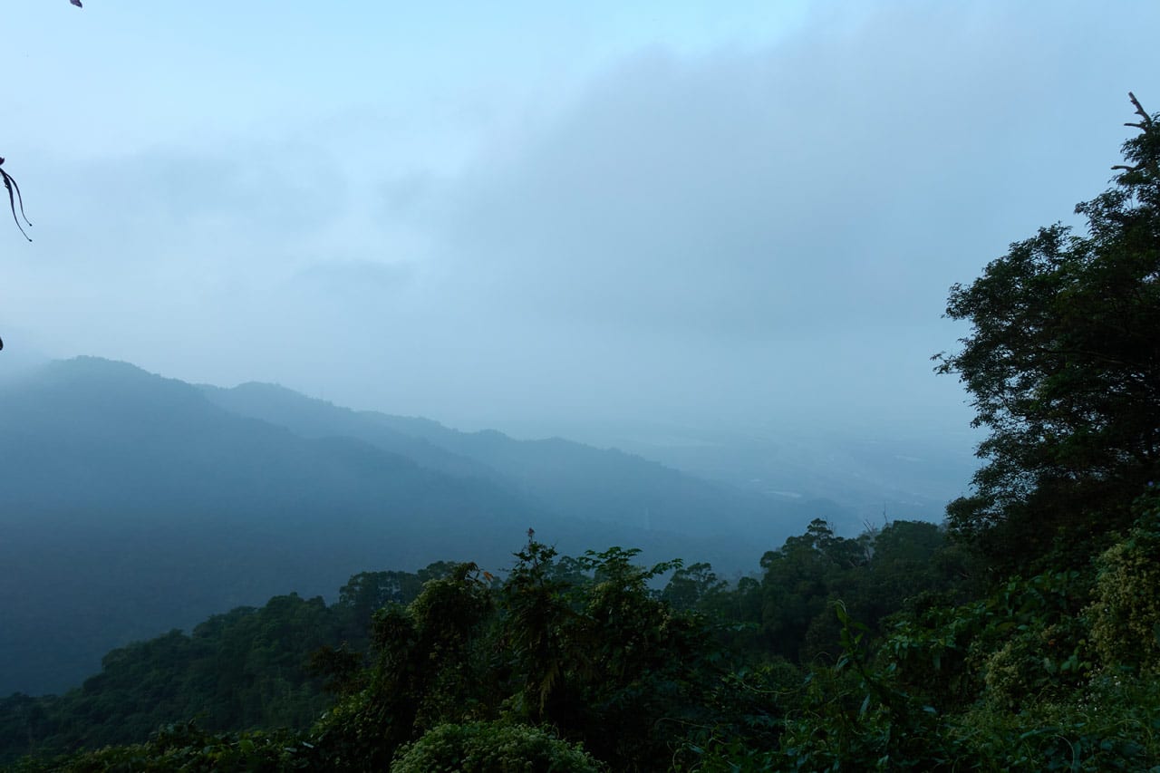
Slowly but surely, light arrived.

If you know me, you know I dislike hiking on roads. I just can’t get the idea out of my head that I have the means to drive it, but instead have to hike it.
This part the hike was by far the most boring.

But eventually there came a decision – continue along the road a ways or cut up a trail to the ridge. I took the ridge trail.

I should briefly mention that there are several different paths you can take to reach PengJiShan. All I’ll say is this: do your research before heading up. A man in a hiking group not long ago lagged behind the bunch and accidentally took a wrong turn and went missing. Luckily he was found alive down in a small stream some days later. I personally wouldn’t consider this a dangerous hike, but his story just goes to show that you never know.
Up to New Heights
The trail up to the ridge isn’t anything spectacular. In fact, I don’t have any pictures of any nice views along the way. So I have to guess that there weren’t any. Or I might have thought that since I had hiked it before, I would just direct you to that post (link above) for a more detailed look.


This stretch of trail will take you to the very first peak of the hike, PengJiXiaShan – 棚集下山.

It’s nothing to look forward to. It’s off on the side of the trail and would be overlooked if not for some ribbons and whatnot marking it. But what IS exciting is that it marks the final short stretch to PengJiShan!

In less than ten minutes you will arrive.
PengJiShan 棚集山 and a Few Others
This was the third time for me to hike to this peak – the last time less than a week ago. As you can probably imagine, I had little motivation to take pictures.


The ground and trees were all wet, so I took a short break under a nearby tarp and then made my way to the next destination, SanChaFeng – 三叉峰.

Woah! Now that was quite a jump in time, huh? In reality it takes about thirty minutes or so to reach SanChaFeng from PengJiShan. But I took no pictures this time. Again, look at the other post for details.
So…SaChaFeng…this is the peak that I’m not sure is a real peak. All you can find is this sign nailed to that tree. There’s nothing else to see there; no ribbons or anything to indicate that this is a place of meaning. For all I know, someone put that there for no reason. Heck, the name isn’t on any maps that I’ve seen. So at best, I’ll label SanChaFeng as a “suspected peak”.
Ok, are you ready for another leap in time?

I passed by BeiJiuJiShan 北久集山 without even snapping a picture. This one was from the week before. But for whatever reason I felt the need to take a picture (again) of JiuJiShan 久集山 when I arrived.

Ok, this will end the massive jumps in time. From here on, I took more pictures and can document the hike like usual. But…I have to tell you that I lied earlier. I said that I had hiked every bit of this trail in sections over the years. That’s not entirely true. The next five-hundred meters after JiuJiShan were all new to me. It’s a short and easy section, so I didn’t think it important to point it out earlier.
The Trail to JiuBaoShan 久保山
From JiuJiShan we’re roughly 7 kilometers into the hike. It’s only another 3 kilometers to JiuBaoShan, but these will be tougher than the previous seven. But not right away. Things were still relatively easy in the beginning.


Yes, it did get a little overgrown from time to time…

…but it wasn’t difficult to hike through it.
After I crossed that five-hundred meters of “new-to-me” trail, I came to a junction.

If for some reason you’re not feeling up to finishing the hike, you can follow this trail down the mountain to a dirt road. But I warn you, it will be a LOOOOOOOONG walk down the mountain…and a long time before you see any houses with people living in them. If you’re lucky, someone might drive by and give you a ride, but the chances are very, very slim. You’re probably better off backtracking the way you came.
Things About to Get Tougher
In addition to marking the trail down to the road, this ribbon also marks the point in the hike where it’s about to get messier and tougher. Though it starts deceptively easy enough.

But eventually the ropes show up.


But it’s still not so bad. In fact, at one point I came across this little cleared section of the mountain.

This was not here the first time I had passed through several years ago. There are chairs, a rake, and a plastic box filled with goodies (that I did not open). And if you look closely at the yellow paint on the tree in the back, it’s in the shape of a person. Well, kind of an alien person.

I was temped to take a break here, but opted to push on.
And as I mentioned earlier…after this spot…things got messy.

It’s difficult to gauge depth in this picture, but as you can see, someone thought it appropriate to tie a rope there. And believe me, it was needed, as the ground was damp.
It’s funny cuz I don’t remember it being this bad the first time I hiked it. That was my very first real (though unplanned) hike. I think I would have abandoned the hike back then if it was this bad. But now…guess I’m just stupid. It was dirty and miserable, but I loved every second of it!

This is also the section of the hike that I found these two beauties.


Ok, you may disagree about their beauty. At any rate, they sure are unique.
Easier Path with Some Danger
It didn’t take long before I broke through all that mess to the other side where things were far more hospitable.


I also found this sign of what appears to be a hiking group? I’m not sure why they posted it or what they’re trying to claim. At any rate, here it is.

As I continued along…


…I encountered a few interesting things.
The first was this bunch of white trees or vines or whatever they were.


I’m not sure if this was caused by a fungus or…*gasp* a ghostly presence…hahaha. As far as I could tell, these were the only ones affected in the area.
The second interesting thing that happened was to me…or kind of to me I guess….was this:
View this post on Instagram
So yeah, I heard some rifle shots nearby. I don’t really think I was in any danger…but you never know with guns. After I took that video I quickly made my exit.

And the third and final interesting thing I encountered not long before reaching JiuBaoShan was this little beauty.

This is a Swinhoe’s Grass Snake (斯文豪氏游蛇, 台灣頸槽蛇) from what I can tell. I was surprised to see that she didn’t try to flee the moment I walked up. From what I’ve read, they’re quite docile. That might have been part of it. But then out of nowhere…this guy came slithering up.
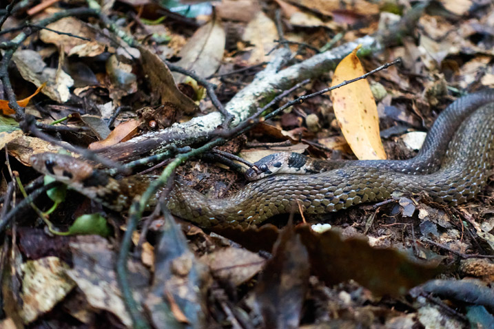

That’s how I knew the she was a ‘she’ and the dude was a ‘he’. Neither seemed at all bothered by my presence. Nor did they seem to care that I was snapping pictures and videoing their late-morning affair.
Grass snakes mating…
I’ve got a few witty comments floating around in my head, but I’ll stick with “Grass snakes mating”. #taiwan #hiking #OutHiking #snakes pic.twitter.com/4lqOBRx5gX
— OutRecording (@OutRecording) November 23, 2020
JiuBaoShan – 久保山

I reached JiuBaoShan about ten minutes or so after seeing the snakes. It wasn’t all that exciting; probably because I had been there before. But I was happy to be able to stop and take a break…albeit, quite a short one.

Here’s a better look at the JiuBaoShan peak.

And some of the stuff you’ll see around it.


Short Journey to the Crossroads
This was another section of the hike that I hadn’t ever hiked. I thought it would be a short little easy bit of trail hardly worth describing…but I was wrong. It took me nearly half an hour and it was STEEP in places.

This was the only picture I took of the steepness. It wasn’t terrible really, and there were ropes…but it just wasn’t something I was expecting.
After the steeper sections came more of the usual scenery I had been seeing on the other side of JiuBaoShan.


Oh, and all over this part of the mountain and beyond, you’ll see these two signs posted.


And once more you’ll see them at the crossroads.

Oh yeah…I’m now at the crossroads.
But what is the crossroads? It’s just the name for the place where four trails meet. From here you can take one of four trails to JiuBaoshan, NanJiuBaoShan, DaWucang and beyond, and down to the old Pailjus tribe – 白鷺部落. (and those glasses have been there for about three years…I don’t think the owner plans to retrieve them)
This is where I needed to make a decision. My time was pretty tight and I didn’t want to finish the hike in the dark. Mainly because I felt bad about leaving my friend down near the Pailjus tribe waiting at night with no word from me (I had no cellphone connection). I had already been to NanJiuBaoShan, so I wouldn’t be missing anything. BUT…I really wanted to finish this hike as a whole. To continue would mean no rest at the next peak. So which path did I take?
Trail to NanJiuBaoShan – 南久保山
Yeah, I chose to push myself to finish the entire thing, my body be damned.
And I’m sorry to say that I only took TWO pictures on the way to NanJiuBaoShan. This of course was because I had already hiked this section. And again, if you’d like to see more of this section, read this post.
Here are those two pictures.


Along the way I was surprised to meet two hikers coming back from NanJiuBaoShan – presumably a married couple. I’m not sure who was more surprised though, as they seemed at a loss for words to begin with.
One other thing I noticed on the hike down to the peak (though I took these pictures on the way back) were these not-so-little dudes on this tree.


They presented a little challenge for me because it was difficult to walk by without nearly brushing up against them. They didn’t seem to notice me at all, but I really didn’t want to chance pissing them off. But the problem was, the trail was tight and there was a drop-off on either side. So I did a silly thing and hung on to a tree on the other side of the trail and sorta swung around until I was past them. That was probably MORE dangerous than just walking by them. (And I’m assuming those two hikers I had met earlier had walked by them twice without noticing them. So…)
Obviously I was successful…and I did walk by them (quickly!) on the return trip without incident.
So…other than meeting those two hikers and being overly-cautious about tree eating (wasps? hornets?) nothing of mention happened.
NanJiuBaoShan – 南久保山
I arrived at NanJiuBaoShan in about one hour and fifteen minutes. It was a super easy hike because it was nearly all downhill.
I didn’t take a peak picture. But here are some shots of some of the stuff to see there.


Even though this section of the hike wasn’t all that difficult, I was till pretty tired overall. A solid hour’s rest was needed, but I worried I wouldn’t make it back before dark. So I only rested about thirty minutes before getting back to the trail – this time uphill… 🙁
The Final Section
It was now nearly three o’clock and I had no time to stop for anything…except this oddity.


My first thought was that it was animal poop. But that didn’t seem right. I posted the pictures on Twitter and an eagle-eyed friend noticed something that I hadn’t.
A small mystery for @TrevorCPadgett. I found this pile of reddish/orange ‘balls’ under this stunted tree. I can’t imagine they came from the tree. Nothing similar on ground nearby. Someone/Something dropped them there? Big pile of fun looking poop? #taiwan #hiking pic.twitter.com/f5RTWVBQ1s
— OutRecording (@OutRecording) November 28, 2020
Ah! So there was some insect inside that tree boring a tunnel and pushing out those balls! Or eating the tree and pooping them out. Whatever it was doing, it did a great job! haha
While on the way back to the crossroads the sky opened up tiny bit.

…if you can even consider that “opening up”. I’m doubtful, but it’s all I got.
I don’t have much else to write. It took some effort, but I made it to the pick up point at five thirty. I was dead tired and ready for a good long rest. I was truly surprised that my friend Shereé had cooked up some hot food and had it ready for me! Let me tell you…eating hot food after that hike was THE PERFECT ending to a great hike. Thanks again Shereé! I owe you one!
My Thoughts on the Hike
That’s all I got for ya. I think this is a great hike for anyone willing to get up really early and hike for ten hours, give or take. It’s nice because it’s kind of a thru hike – with the exception of the backtrack after NanJiuBaoShan. And if you decided you were too tired or lagging behind schedule, there are plenty of places you can cut the hike short. So a lot of options there. So yeah, I recommend this hike!
Date hiked: 2020 Nov 22
GPX Track Download Instructions: Click the track on the map to see the download link


![[Valid RSS]](https://outrecording.b-cdn.net/wp-content/uploads/2020/03/valid-rss-rogers.png.webp)
Love your blog and your hiking reports. That experience with the gunshots reminded me of a time years ago when I was hiking in Taichung’s Xintian area. I was taking a break on top of a hill, and while looking down at a road in the distance, I saw a car park at the side of the road and three men get out and walk into the woods. A few minutes later there was a loud sound like that of a gunshot, and then two men reappeared from the woods, got back into the car and drove off. I checked the news for days afterward for reports of an execution-style murder discovered in the hills of Tanzi, but there was nothing.
Wow! That would have been something to witness! I’m probably stupid enough to have hiked up to where they stopped the car and taken a look. But glad you didn’t. Who knows, there might still be a body up there.
And thanks for the feedback! Much appreciated.