

XinZhiShan 新置山 is a small mountain that sits directly behind Laiyi 來義 village in Pingtung. I’ve driven by it countless times and have always wanted to hike to its modest 619 meter peak. The end of last January, I decided to give it a try.
In my mind, XinZhiShan was going to be an easy hike. Being right next to a well populated area I envisioned a well traveled trail with several locations claimed by the locals with folding tables, plastic chairs, and tarps. In reality, it was nothing like this at all.
There are three routes you can take to get to XinZhiShan. I thought my best bet would be the trail that starts in the village itself. I found an elevated area close to the trail head to park my bike.

This place seemed mostly forgotten. By the looks of it, I would guess that the village uses it for festive activities. This was a perfect place for me to park.
A short walk down from here and I arrived at the trail head.

There was a sign on the ground off to the left.

I followed the trail and it was looking good in the beginning.

It even offered a nice view of the village below.

As I hiked along, there was evidence of trail maintenance. That was a good sign.

All of this made me think I was going to have an easy-going hike. Boy was I wrong!
About 15 minutes into the hike the main trail continued on, nice and maintained, but the trail to XinZhiShan cut up into the trees.

All in all, it still looked pretty decent.

Until…
I ran into my first trap.

It was low to the ground and obviously meant to snare something small. I easily walked around the trap and quickly found another one…

…and another one…

…and another one.

I found so many traps that I stopped taking pictures. They were EVERYWHERE.
Most were easy to walk around, but some weren’t. You could see holes all around that were dug for old traps in the past. I’ve encountered traps before, but I have never seen this many traps in such a small area. It was ridiculous.
In the middle of all these traps I saw a promising sign. Literally…a sign…

It directed me to take a right. However, there appeared to be some tiny peak a short hike off to the left. So I followed the left path.
A very short hike later and I arrived at GuLou 古樓.


I didn’t even see this listed on any maps, but hey, I’ll take it! Considering that the sign doesn’t have “mountain” written on it, maybe it’s just a random triangulation point. I’m really not sure…
I made my way back to the fork and continued up towards XinZhiShan. I came across even more traps along they way. But at some point I stopped seeing them. And that was exact spot where the trail went from “well worn” to “is there trail here, cuz I’m not really seeing it?”. 😐
I spent the next 30+ minutes using my machete A LOT. This was pretty much what I was seeing in all directions:


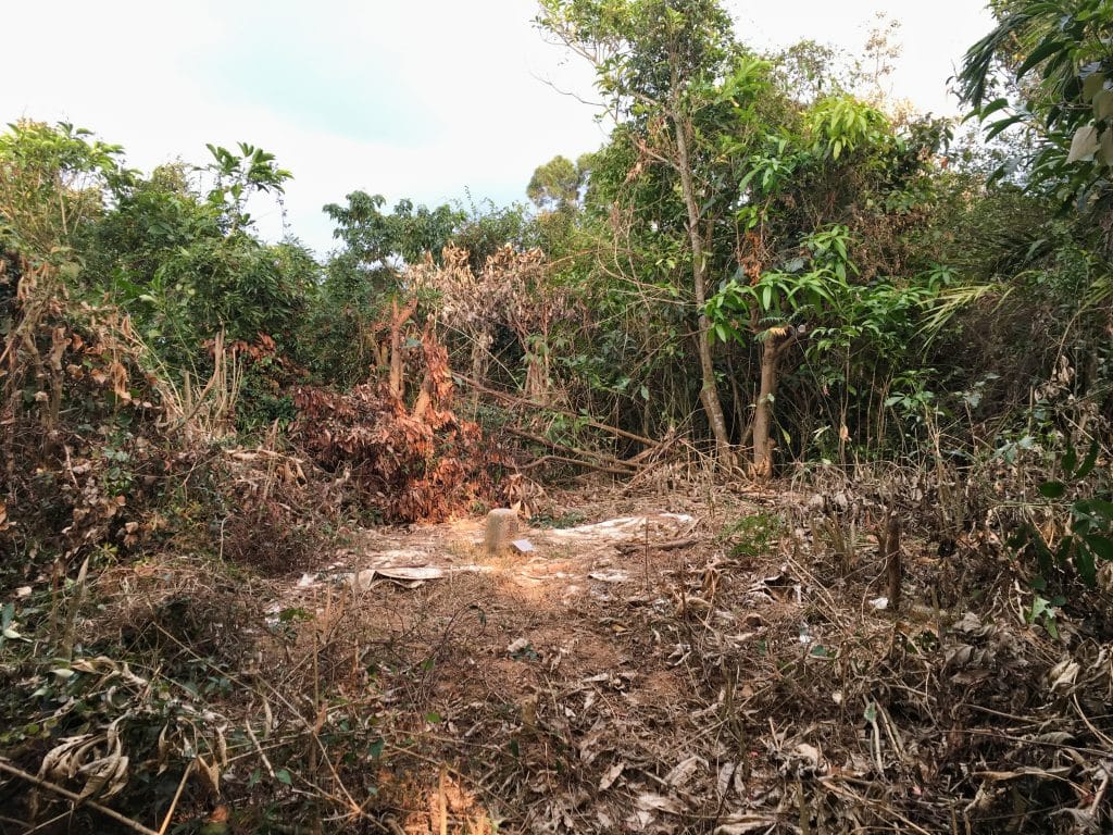
I hacked my way up as far as I could go but remember, I was looking for an easy hike. I had hoped this would just be a patch of wild section that would end soon, but it didn’t seem to be. I made it as far as this little nameless marker.


It appeared–at least on this day–that this trail had been abandoned. But as I mentioned, there are three trails that lead to XinZhiShan. Of the two remaining, one is pretty short…the other longer. Given that I had wasted a fair amount of time on the first trail, plus the time it would take to drive to the next trail head, I chose the shorter route.
The shorter trail is located on the backside of the mountain. You drive up a farmer’s road that takes you to within one kilometer of the peak. And like the first trail head, this one looked promising.

This area looks to have been used for farming before. But nothing was being grown now.
I found a trail up the ridge and made my way up. There was overgrowth in the beginning but it wasn’t too dense. I could get through with a minimal amount of machete work. But the further I got, the worse the conditions got.

Eventually it started looking more and more like the first trail.

At first I thought, “It’s just 1000 meters…it might take some time but it’s not THAT far”…so I pushed on. Well, after about 50 minutes I had made it all of 150 meters. At that rate, I was looking at several hours of hard work. It didn’t seem worth it. So I admitted defeat and headed back down.
There’s a bunch of coffee shops on the other end of the mountain. I drove to one to take a break and figure out my next move.

I didn’t have time to attempt the third route to XinZhiShan. But I DID have time to take a look at the trail. If it looked good I could come back another day to hike it. So after a short rest at the coffee shop I drove to the third trail head.
This one was harder to reach. I had to drive through a small village and up a zig-zag of dirt trails through a large mango farm. At the top was a nice dirt “platform” to park my bike.

Beyond this point was a steep trail.

I hiked to the top and what I saw made me happy.

There was a huge tangle of trees and vines. But someone had cut a hole right through them! So it appears that this is the only working trail to XinZhiShan. That was my thought at the time. Looking at my map, I found that TouLunShan 頭崙山 was only about 350 meters from the trail head. I had plenty of time to reach it. Heck yeah! I want my consolation prize! haha…
I went back to my bike, geared up, and started my short hike.
The view along the ridge was decent…

…but most of the way was filled with spider webs and an extremely overgrown ridge.


From what I could tell, someone had come through here with a chainsaw. The larger branches had too clean of a cut to have been anything else. I can only guess that the government had paid someone to keep this trail clear.
After a bit more overgrowth…

…I made it to TouLunShan.
As you can see, this area was purposely cleared. In front of the triangulation point is a little sign.

It basically explains what this “rock” is used for and asks that you don’t put garbage on it or mess with it in any way.
As usual, I took my peak pic.

After I nice long rest and some food, I looked around for anything hammered to the trees.


Other than these two makeshift signs, the only thing interesting was this lizard that oddly let me get extremely close to it.

It must have liked my music. Because once I turned it off, it disappeared.
Before I left I looked for a trail leading in the direction of XinZhiShan. I couldn’t find one. Whoever chainsawed their way to TouLunShan didn’t continue further. It appears that this is the end of the line. 🙁
I’m kind of bummed about it. As of the date of this hike there appears to be no clear way to reach XinZhiShan. Perhaps the government or some overzealous hikers might open up a trail in the future. If you want to try it before that happens, I would recommend the second trail I tried; the one at the back of the mountain. It will still take some time, but at least it’s only one kilometer. I may try it one day for the hell of it. But only in the winter months when all that overgrowth is dead.
If you’re ever up there and you find that a trail has been cleared, please let me know. Thanks!
Date hiked: 2019 January 31
GPX Track Download Instructions: Click the track on the map to see the download link
I’m included the two failed attempts to XinZhiShan for your reference.

![[Valid RSS]](http://outrecording.b-cdn.net/wp-content/uploads/2020/03/valid-rss-rogers.png.webp)
2 Comments