
Ride Info
This is a great group of scenic trails that doesn’t require a great bike unless you plan on hitting the riverbed. There are plenty of trails I didn’t try on this trip, which can be seen on google maps – if they can be believed. There’s a guard station here: 22.817370, 120.677477 I’m told you MUST have a permit to enter. I was turned away last year by a guard. This trip though, nobody was there and the gate was open. I saw a few trucks on the trail carrying guard rails, re-bar and other items. The guard might have been off with them down the trail. I decided not to press my luck since there’s a sign in clear English saying you need permission.
Note! You may currently enter the former restricted area. Guards are no longer stationed at the checkpoint and the gate is down. Enjoy!
There is a mostly abandoned road starting here: 22.814569, 120.660566 It will take you about halfway down before the road disappears. You can take this side trail approximately here: 22.811216, 120.651184 past a farm that links up with the road later below. Be careful, there’s one particularly tight and dangerous switchback.
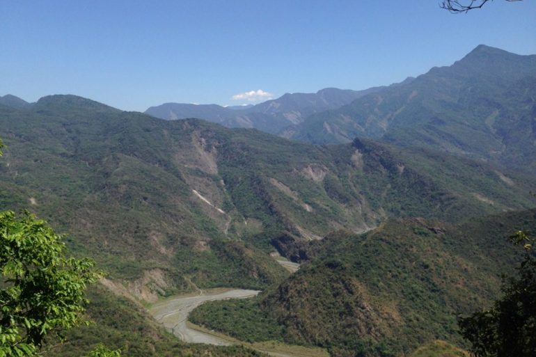
If you want to go to the river you can take this path: 22.765205, 120.655674 It looks like it used to be something for tourists. Unless you plan on driving down the river to get out, you had better have a decent set of tires and a bike with enough power to get you back up that steep trail. The first time I was there on my Hartford with a crappy rear tire and 200cc engine. I couldn’t make it up. Luckily a couple poachers came by and gave me a push. (yeah, poachers!)
Heading east up the river for a couple kilometers will take you to a little water pool. Only minor water crossings to get you there. It would be a nice place for a cool-off. I didn’t want to venture much past that area; it was getting rockier and I didn’t think my bike would make it.
I also tried getting to the river further down the trail, closer to the guard shack. The trail eventually turned into a hiking path. I believe I could have made it, but I was feeling too tired at that point to battle through that technical of a trail. Here’s how far I made it: 22.801447, 120.667255 At some point on this trail you’ll be going uphill a bit, then reach a 90 degree left turn. There was some warning tape here. If you miss the turn, say goodbye. There isn’t much room for error. Approximately here: 22.799808, 120.665680
Ride Start:
Date:
2015 Apr 01
Notes
- There’s a campsite here: 22.800704, 120.664207 Take this side trail to get there: 22.798973, 120.663758 There’s plenty of room for several tents. The view is nice. Unfortunately there’s a lot of garbage thrown into a little ravine off to the side. NOTE! When I last went the end of November 2015, there was a landslide shortly after the trail head that will block bikes from getting through. It may be cleared by now. It’s worth checking out.
- There’s an abandoned building here: 22.783407, 120.662295 A fun place to check out or shelter if it rains.
- An abandoned partial shipping container sits at the side of the road. Nothing interesting about it. But could be used as shelter if needed. Here: 22.815474, 120.655052
- There’s an interesting half-destroyed old suspension bridge at the end of the ride: 22.764887, 120.647895
GPX Track Download Instructions: The map won’t display this GPX track; likely because I cobbled many tracks into one. Here’s the direct link: CLICK HERE FOR LINK
Gallery


![[Valid RSS]](https://outrecording.b-cdn.net/wp-content/uploads/2020/03/valid-rss-rogers.png.webp)
1 Comment