• Home
  • Taiwan Off-Roading
  • About Me
    • About Me
    • Liability Disclaimer
  • Contact
  • 語言: 中文 (台灣)
    • English English
    • 中文 (台灣) 中文 (台灣)
OutRecording
Menu
  • Home
  • Taiwan Off-Roading
  • About Me
    • About Me
    • Liability Disclaimer
  • Contact
  • 語言: 中文 (台灣)
    • English English
    • 中文 (台灣) 中文 (台灣)
Home  /  Taiwan Off-Roading  /  Chunri Riverbed near Laochijia – (老七佳)
19 五月 2017

Chunri Riverbed near Laochijia – (老七佳)

Written by Glenn
Taiwan Off-Roading chunri, GPS, gpx, KLX250s, Laochijia, motorcycle, Nanhe, Pingtung, riverbed, Taiwan, waterfall, 南和, 春日, 老七佳 Leave a Comment

Sorry, this entry is only available in 美式英文

Ride Start:

22.441312, 120.670874


Date:

Many times during the dry months (Winter)


Ride Info

This ride begins at Nanhe 南和 in Laiyi Township, but most of the ride is in Chunri Township. This is another favorite riverbed of mine as it offers plenty of sections to open up your bike, as well as very difficult technical sections not for the lighthearted. Pretty much any motorcycle can make it down the main riverbed. Heck, a car could make it to the halfway point. It gets slightly harrier towards the end, but nothing terribly difficult. The challenging part is the section that splits off near Laochijia. There never seems to be much of a trail and the going is always tough.

To get to the Laochijia section of the ride, you can either follow the river where it splits here: 22.446408, 120.686637 or take the mountain road to get to the bridge here: 22.438974, 120.692067

2015-02-27 11.01_web.46

If you choose the river, there’s sometimes a road that will take you easily to the bridge. If it’s not there, the going won’t be easy, but it’s doable. Where the river splits you’ll see an old house-like structure half buried off to the right. Can’t miss it. Casualty of Typhoon Morakot no doubt.

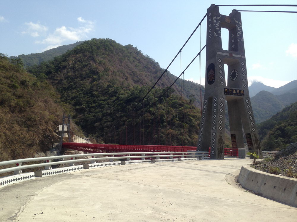
If you choose to take the mountain road you’ll need to cross the bridge and take a somewhat steep trail down to the riverbed here: 22.439188, 120.694318 It’s never in good shape and sometimes challenging just to make it down. There used to be an easy road that would take you to the riverbed just off to the side of the above picture. But a landslide took part of it out a couple typhoons ago. I’m sure it will be rebuilt at some point.

The road on the other side of the bridge will take you to Laochijia village. There used to be a gate barring entry…

2015-02-27 11.08_web.46…but the last time I went up there it was gone and you could presumably ride all the way to the village. 
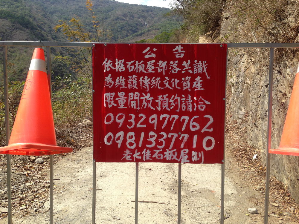
However, unless things have changed I wouldn’t go up there. I’ve been told you need permission and/or guide to go there. (Read below in red) It’s an old aboriginal village and is/was trying to get listed as a world heritage site. More info here: The View from Taiwan.

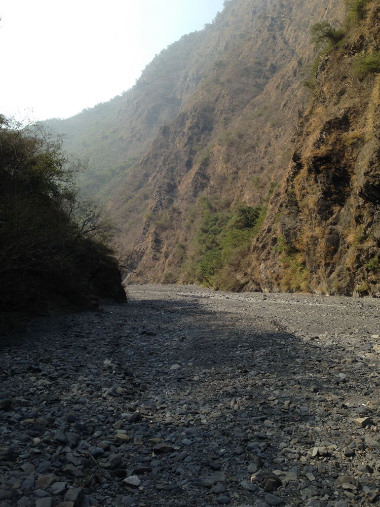
Back to the river, I’ve made it decently far up this stretch of river the first time I tried but couldn’t get passed one particular rocky section. Maybe if a few riders were with me I would have went for it. Passed that section was a nice open, easily ride-able stretch of beautiful riverbed.

2015-02-27 14.44_web.44

I hope to make it that far again. Ever since then conditions haven’t been very good. Bring your buddies and plenty of energy!

If you want to skip this part for another day (I wouldn’t try riding both sections on the same day, assuming you can make it decently far down the above section) head up the main river past the half sunken house.

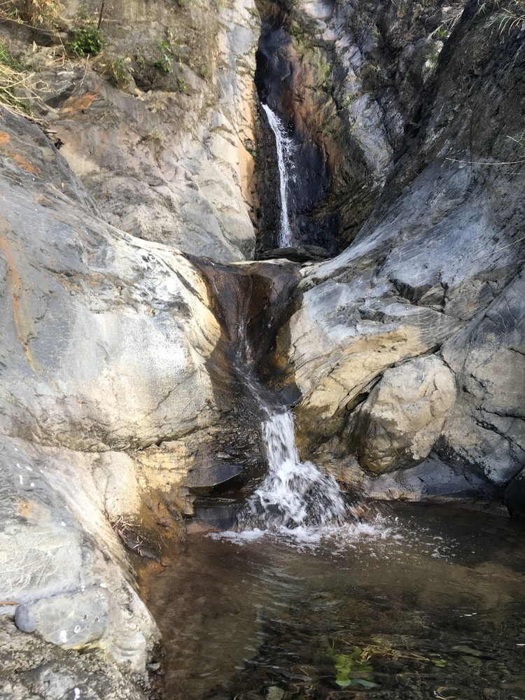
There isn’t a whole lot to see on this riverbed. There appears to be a waterfall here: 22.454402, 120.707529 that I haven’t visited. And I’ve seen evidence of dry waterfalls, but by and large there isn’t much else. I’ll usually stop at one smaller waterfall to eat and enjoy the shade, here: 22.453087, 120.720007. 

2017-01-05 16.14_web.00

There are usually some frogs and crabs to watch. Out on the riverbed I’ve seen some pheasant-like birds that sit there like a rock trying to blend in and will suddenly jump up and fly away as you get near them. I’d really like to know what they are.

As a point of interest, this waterfall has changed every time I visit. The first time you could walk right up to it. Now you have to climb a little.

2017-01-05 19.51.41_web

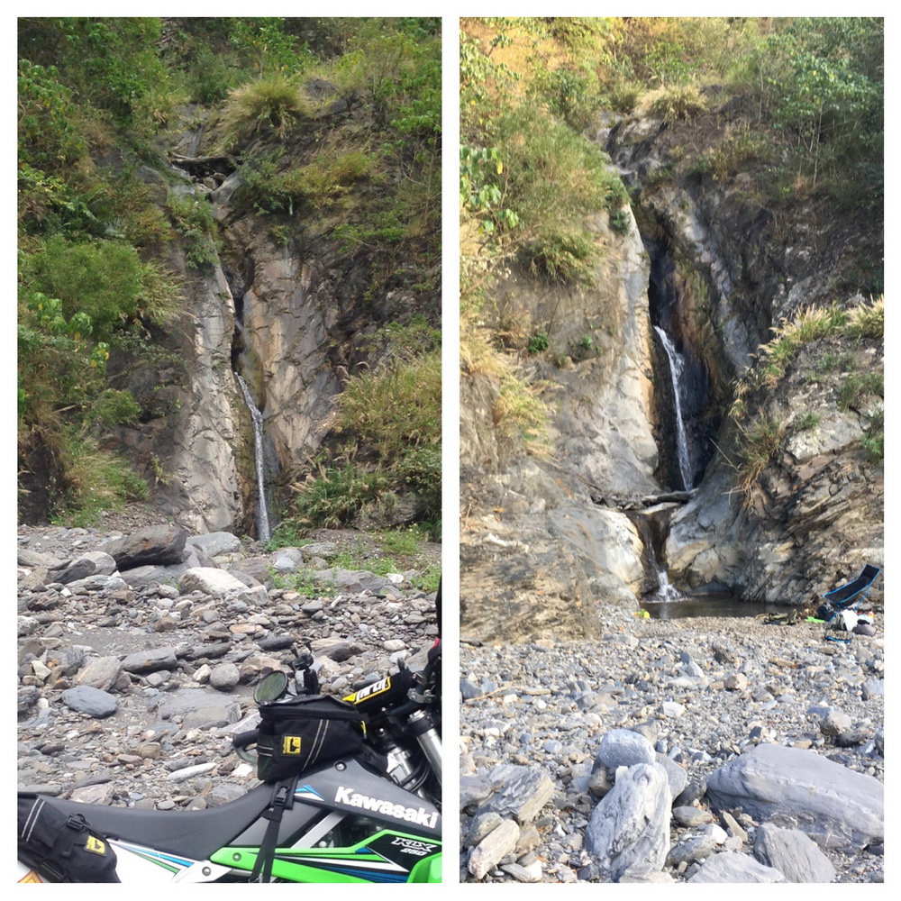
Morakot brought a lot of the surrounding mountains down into the river. With every passing typhoon all that new rock gets slowly removed. The above picture is only about one year apart.

At the very end of my GPS track there’s still plenty of riverbed left to go but it’s nearly impossible to continue by bike. I’m hoping after a few more typhoons the rocks will be cleared away more. And if you still have time left, there are plenty of nearby mountain trails to explore.

***As of 2019, you can’t drive quite as far. I suspect as the years pass the trail will get shorter and shorter. Also, the road up to Laoqijia village no longer has the gate near the bridge. You can drive nearly to the village before reaching another gate.***


Notes

  • Have a Plan B ready in case you can’t get far. Riverbeds in Taiwan are hit or miss; though this one is usually OK.
  • It’s a good idea to track a riverbed ride with any GPS tracking device you have available. You can’t technically get lost on a riverbed…just head down-river…but there will be times when you lose the trail and drive around aimlessly looking for it. Yes, it’s part of the fun, but it will save your butt when it’s nearly dark and you’re still out there. Believe me, I know!
  • Wear full protection if you plan to ride the Laochijia section. This would only be for smaller bikes. Big bikes, forget it
  • You’re likely to encounter farmers on the riverbed. Some will be nice and smile/wave while others will give you a dirty look. I’ve encountered people out on riverbeds doing things they’re not supposed to be doing (poaching/illegal hunting). I doubt you’ll find trouble, but still, be aware.


Map loading, please wait ...


Gallery


2015-02-27 10.43_web.55
2015-02-27 11.01_web.46
2015-02-27 11.02_web.08
2015-02-27 11.03_web.05
2015-02-27 11.03_web.34
2015-02-27 11.03_web.43
2015-02-27 11.03_web.50
2015-02-27 11.03_web.59
2015-02-27 11.04_web.54
2015-02-27 11.08_web.46
2015-02-27 11.29_web.02
2015-02-27 11.31_web.14
2015-02-27 11.32_web.03
2015-02-27 11.32_web.12
2015-02-27 12.37_web.48
2015-02-27 12.37_web.51
2015-02-27 12.41_web.17
2015-02-27 12.43_web.57
2015-02-27 12.44_web.03
2015-02-27 12.44_web.07
2015-02-27 12.53_web.57
2015-02-27 13.01_web.49
2015-02-27 13.01_web.54
2015-02-27 13.02_web.14
2015-02-27 13.06_web.04
2015-02-27 13.08_web.33
2015-02-27 13.13_web.45
2015-02-27 13.16_web.08
2015-02-27 13.16_web.15
2015-02-27 13.18_web.01
2015-02-27 13.19_web.58
2015-02-27 13.24_web.53
2015-02-27 14.02_web.15
2015-02-27 14.23_web.08
2015-02-27 14.44_web.44
2015-02-27 14.47_web.04 HDR
2015-12-24 12.21_web.22
2015-12-24 12.35_web.33
2015-12-24 12.36_web.30
2015-12-24 12.36_web.47
2015-12-24 13.12_web.53
2015-12-24 13.13_web.09
2015-12-24 13.13_web.14
2015-12-24 13.13_web.35
2015-12-24 13.14_web.30
2015-12-24 15.11_web.51
2015-12-24 15.33_web.30
2015-12-24 15.33_web.37
2015-12-24 16.01_web.49
2015-12-24 16.01_web.52
2015-12-24 16.17_web.12
2015-12-24 16.17_web.19
2015-12-24 16.17_web.28
2017-01-05 10.41_web.59
2017-01-05 11.26_web.19
2017-01-05 11.32_web.56
2017-01-05 12.45_web.15
2017-01-05 14.01_web.44
2017-01-05 14.02_web.47
2017-01-05 16.02_web.58
2017-01-05 16.08_web.56
2017-01-05 16.09_web.03
2017-01-05 16.09_web.34
2017-01-05 16.14_web.00
2017-01-05 16.22_web.37
2017-01-05 16.43_web.47
2017-01-05 16.43_web.56
2017-01-05 19.51.41_web

Liability Disclaimer

Please read the Liability Disclaimer before using any information within this post, page or any part of this website.

Share On
Share on Facebook
Share on Twitter
Share on Pinterest
Share on Reddit
 Previous Article Waluxi Riverbed 瓦魯斯溪
Next Article   Taiwu Trails (泰武)

Related Posts

  • Mountains and blue sky in the distance - trees in foreground

    (English) Hike to PengJiShan, North JiuJiShan, and JiuJiShan – 棚集山, 北久集山, 久集山 via Alternate Back Trail

    二月 28, 2021
  • Mountains and blue skies in distance with clouds - dead tree in foreground

    (English) Hike to BaiBinShan and ZhenLiShan Northeast Peak in Majia – 白賓山, 真笠山東北峰

    一月 31, 2021
  • rolling green mountains - blue sky and ocean - white clouds

    (English) Hike to QiLuZhiKeShan – 耆路知可山 in Shihzih, Pingtung County

    十月 26, 2020

發佈留言 取消回覆

Hiking in Taiwan & Offroad Motorcycling

  • Popular Posts
  • Recent Posts
  • Tascam DR-680 Noise Test 一月 16, 2014 10
  • 巴層巴墨山的登山趣, 屏東縣獅子鄉, 台灣 三月 3, 2019 8
  • WaiMaLiBaShan 外麻里巴山 - view of mountains and river below
    (English) Hike to WaiMaLiBaShan 外麻里巴山 in Shizi, Taiwan 三月 18, 2019 6
  • Panoramic shots of mountains see on the JiuBaoShan 久保山 trail
    越野 & 徒步登山上久保山 四月 15, 2018 5
  • Mountains and blue sky in the distance - trees in foreground
    (English) Hike to PengJiShan, North JiuJiShan, and JiuJiShan – 棚集山, 北久集山, 久集山 via Alternate Back Trail 二月 28, 2021 0
  • 鱈葉根山 - XueYeGenShan featured image - two signs attached to tree
    (English) Hiking to XueYeGenShan 鱈葉根山 in Majia, Taiwan 二月 9, 2021 0
  • Mountains and blue skies in distance with clouds - dead tree in foreground
    (English) Hike to BaiBinShan and ZhenLiShan Northeast Peak in Majia – 白賓山, 真笠山東北峰 一月 31, 2021 0
  • MeiLunShan 美輪山 trail sign
    (English) Hiking to MeiLunShan – 美輪山, in Kaohsiung, Taiwan 十二月 17, 2020 0


OutRecording @OutRecording
4
Here's another tree question. Do trees just up and say, "You know what? I don't want my bark anymore!" and go and shed it? I don't think so, but I found this and it didn't appear to have been scraped off by an animal. #taiwan #OutHiking #hiking #tree https://t.co/lwdjzDX7Ov

- 3 hours ago

Follow @outrecording

Social Media

  • Connect on Twitter
  • Connect on Instagram
  • Connect on YouTube
MY HIKING GEAR SPONSOR

Six Moon Designs Logo

近期留言

  • 「Glenn」在〈WeiLiaoShan Hike – 尾寮山〉發佈留言
  • 「TEO K H」在〈WeiLiaoShan Hike – 尾寮山〉發佈留言
  • 「Glenn」在〈巴層巴墨山的登山趣, 屏東縣獅子鄉, 台灣〉發佈留言
  • 「Joestar chuang」在〈巴層巴墨山的登山趣, 屏東縣獅子鄉, 台灣〉發佈留言
  • 「Glenn」在〈越野 & 徒步登山上久保山〉發佈留言
TAIWAN RELATED OUTDOORS BLOGS & SIMILAR TOPICS

分類

  • 17

Random Posts

  • (English) outrecording.com 2019 Year in Pictures 二月 17, 2020
PRIVACY POLICY

Copyright © 2020 by outrecording.com. All Rights Reserved. Please read this Disclaimer / Privacy Policy before using any information on this site.

 [Valid RSS]